
Good Spirit Lake Watershed Association Board No. 6
Current Gate Operations - 2026
May 15, 2026 ~ Good Spirit Lake - Update - This document outlines the current lake level, the Water Security Agency 2026 spring run-off forecasts that were utilized to make Good Spirit Lake Watershed decisions, when the gates were opened, and how the current lake levels compare to historic floods. The Watershed would like to remind everyone to use caution within the lake due to fast-moving water and higher lake levels. Due to the water levels the gates will remain open for the forseeable future.
May 2, 2026 ~ The gates have been opened.
April 10, 2026 ~ The Watershed Board is monitoring the lake levels closely. Lake level as of April 10, 2026 is 1589.52 ft (484.485 m).

Good Spirit Lake Watershed Association
The Good Spirit Lake Water Association was established in 1986 under provincial law, and is made up of members from the R.M. of Good Lake #274, the R.M. of Buchanan #304, the R.M. of Invermay #305, the R.M. of Insinger #275, and the Good Lake and Buchanan Conservation and Development Area Authorities. Each of the member municipalities and C & D Authorities pay annual levies to administer and maintain the Watershed Association.
Current Board Members:
- Myron Kopec, Chairman - R.M. of Buchanan
- Dave Popowich, Vice Chairman - R.M. of Good Lake
- Julius Dziaduck - R.M. of Good Lake
- Donald Hrywkiw - Buchanan C & D
- Dwayne Kitzan - R.M. of Insinger
- Ernie Kozak - R.M. of Good Lake
- Regan Graham - R.M. of Invermay
- Darryl Stevenson - R.M. of Good Lake
- Colby Wolkowski - Good Lake C & D
Good Spirit Lake Lake Level
Click here to see the daily lake levels of Good Spirit Lake as plotted by the Saskatchewan Water Security Agency.
Good Spirit Outlet Structure Project - Completed in 2022
In December 2020, the outlet structure renewal project was approved by the Board. Since the approval, the Board worked with MPE Engineering from Saskatoon to move this project forward.
On March 12, 2020 a site assessment/condition assessment was conducted by MPE Engineering. The Board received the report and recommendations on March 26, 2020. For a full copy of the report (click here).
In the fall of 2022 the project was completed, and included the following work:
- remove and replace existing 1200 mm CSP pipes with new 1200 mm CSP outlet pipes
- remove and replace two (2) existing 1200 mm sluice gates, remove and reuse the 1200 mm 2014 sluice gate
- excavate and remove sandy backfill at edges of sheet piling, replace with imported clay fill and backfill past edges of sheet piling
- install erosion protection to protect against wave action
Watershed Operating Guidelines
Summer Water Releases
- When spring runoff or rains causes lake levels to rise above the desirable summer operating range of 1589.5 ft. to 1590 ft., water will be released until the desirable summer levels are reached.
- If the water level after spring runoff or rain is below the desirable summer operating range, no water is released.
Fall Water Releases
- If the lake level is above the range of 1589 ft. to 1589.4 ft. in the fall, water will be released until the lake level is in this range. Variations within the fall target range would be based on the capacity of marshes and sloughs in the watershed area to hold spring runoff. Minor variations outside the fall target range would be based on extremely wet or dry fall conditions.
- If the fall water level is below 1588.65 ft., no water will be released under any circumstances.
Our challenge is this: Let enough water out in the fall so that there is less chance of cabins flooding during spring runoff, yet keep enough water in so that the lake level is acceptable in case there is no spring runoff.
The Watershed Board, with the guidance of provincial engineers and hydrologists from the Saskatchewan Watershed Authority, work to manage the lake level based on historical data and probability, current lake levels, and capacity of the marshes and sloughs in the watershed area to hold spring runoff.
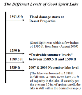
The Different Levels of Good Spirit Lake
Why does the Watershed Board lower Good Spirit Lake in the fall? (only when necessary as per the above guidelines)
To reduce the potential for flooding of resort property, the lake has to have enough capacity in the fall to hold most of the spring runoff. On average, spring runoff and spring rains increase the lake level about 10 inches. But spring runoff has been as much as 4 feet, and as low as 1/4 inch. We have to be reasonably prepared for the big runoffs, like in 2006, 2007 and 2011.
 If the lake floods in the spring, why doesn't the Board open the gates and let the water out then?
It is impossible to let the water out as fast as it comes in. In spring, when all the creeks and rivers are full, only 1 to 2 inches of water per week will go out of the man-made gate and outlet channel. That's not much when 2 or 3 feet of spring runoff could come racing into the lake over a 2-3 week period.
Desirable Summer Levels
Boaters generally like the lake high (1590 ft. or more), and beach users/dune walkers like the lake a bit lower (1589.5 ft. or less). When lake levels allow, the Board tries to provide balance between the two groups of recreational users, keeping in mind the erosive effects that high water levels and wave action can have on the shoreline.
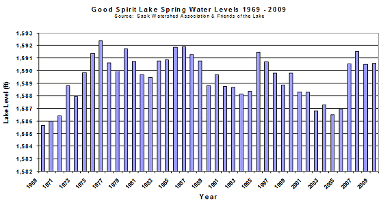
A Fluctuating Lake
Over the past 41 years the level of Good Spirit Lake has fluctuated significantly. The graph below shows the historical highs and lows. Note that flood damage of resort properties begins at 1591.5 ft.
What does the Watershed Association do?
The Good Spirit Lake Watershed Association operates and maintains the outlet control structure at the south end of Good Spirit Lake. This is done with four objectives in mind:
- Accommodate spring runoff into the lake
- Help prevent flooding and erosion of property adjacent to the lake
- Reach a desirable summer lake level
- Minimize downstream flooding
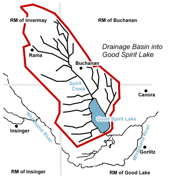 Upstream Drainage
As seen on the map, approximately 1,000 square kilometers of land naturally drains into Good Spirit Lake. Some of this land has also been improved, in that provincially-approved ditches are in place to drain otherwise unusable land and make it available for farming. This generates tens of thousands of dollars of income on an annual basis for farmers in the area.
Recreational use of Good Spirit Lake
There are hundreds of cabins at Burgis Beach, Canora Beach, the Provincial Park and other resorts. As well, the beaches and sand dunes are a tourist attraction, and boating and fishing are popular.
Good Spirit Lake is shallow (average depth 20 feet) and fluctuations in the lake levels become very visible. A summer water level of between 1589.5 feet and 1590.0 feet elevation is targeted by the Board, but reaching these levels is highly dependent on adequate amounts of spring runoff.
Outlet Structure Renewal Project
Burgis Beach flooding, 1985
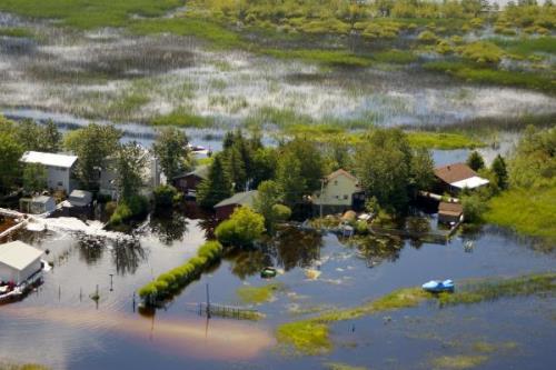
Burgis Beach flooding, 2010, same location
One of the objectives of managing the lake level is to reduce the risk of flooding. Flood damage to resort property begins at a water level of 1591.5 feet, and there are municipal restrictions on building development for most lots in the R.M. of Good Lake. High water levels and wave action can erode shorelines, beaches, and the sand dunes.
Downstream from Good Spirit Lake
The timing and amount of water release has to be done in consideration of its effect on grain/hay land, trails, Ducks Unlimited projects, wells and property downstream from Good Spirit Lake. Water from Good Spirit Lake ultimately ends up in the Whitesand River south of Canora.
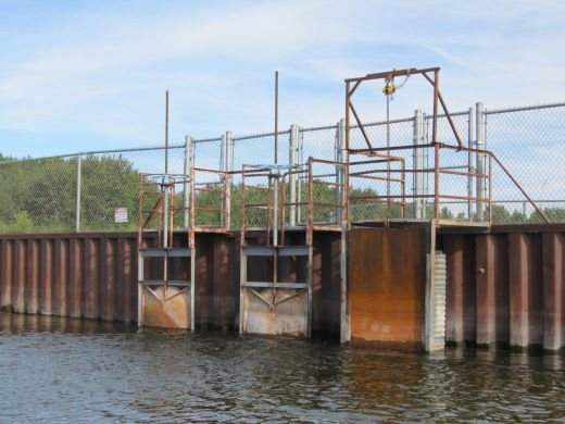
The control structure is at the south end of Good Spirit Lake. There are three large culverts that are controlled by gates.
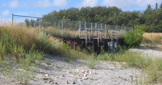
The control gates are shown above, high and dry from 2002 to 2005. Below, the lake water is much higher and the gates are open (2012).
The control structure at the south end of the lake was opened and water let out of the lake during the following times from 1995 to 2011:
- April 28 to July 3, 1995
- October 14 to December 16, 1995
- November 3, 1996 to April 20, 1997
- October 23 to December 2, 1997
- December 5, 1998 to February 4, 1999
- November 15, 1999 to March 3, 2000, winter draw down to 1588.3 feet
- April 24 to July 14, 2006, no fall draw down, lake left at 1589.39 feet
- March 24 to August 8, 2007, close to flooding in the spring of 2007
- Oct 7 to November 15, 2007, fall draw down to 1588.94 feet
- July 21 to August 20, 2008
- May 19 to June 12, 2009
- August 26 to September 15, 2009
- November 18 to November 24, 2009
- May 5, 2010 through winter 2011
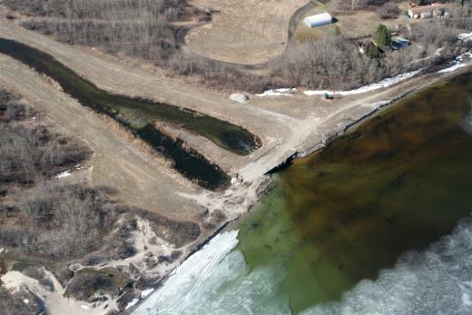
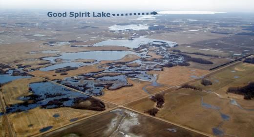
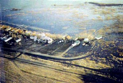
Aerial photo of control structure area and drainage channel